
Mapa topográfico Ladakh
Mapa interativo
Clique no mapa para exibir a altitude.
Sobre este mapa
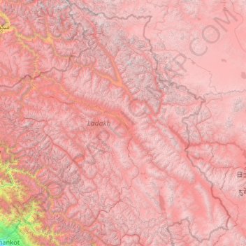
Nome: Mapa topográfico Ladakh, altitude, relevo.
Local: Ladakh, India (32.33574 75.32697 35.67455 79.46075)
Altitude média: 4.726 m
Altitude mínima: 337 m
Altitude máxima: 7.470 m
The Kargil War of 1999, codenamed "Operation Vijay" by the Indian Army, saw infiltration by Pakistani troops into parts of Western Ladakh, namely Kargil, Dras, Mushkoh, Batalik and Chorbatla, overlooking key locations on the Srinagar-Leh highway. Extensive operations were launched in high altitudes by the Indian Army with considerable artillery and air force support. Pakistani troops were evicted from the Indian side of the Line of Control which the Indian government ordered was to be respected and which was not crossed by Indian troops. The Indian government was criticised by the Indian public because India respected geographical co-ordinates more than India's opponents: Pakistan and China.
Outros mapas topográficos
Clique em um mapa para visualizar sua topografia, sua altitude e seu relevo.
Bengaluru
India > Karnataka > Bangalore North
Bengaluru, Bangalore North, Bengaluru Urban District, Karnataka, India
Altitude média: 881 m
Pune
India > Maharashtra > Pune City > Pune
Pune, Pune City, Pune District, Maharashtra, 411001, India
Altitude média: 641 m
3d
India > Rajasthan > Ganganagar Tehsil > 1 LNP
3d, 1 LNP, Ganganagar Tehsil, Sri Ganganagar District, Rajasthan, India
Altitude média: 178 m
Varanasi
India > Uttar Pradesh > Sadar
Varanasi, Sadar, Varanasi District, Uttar Pradesh, 221001, India
Altitude média: 77 m
Hosur
India > Tamil Nadu > Hosur
Hosur, Krishnagiri District, Tamil Nadu, 635109, India
Altitude média: 859 m
Bachupally mandal
Bachupally mandal, Medchal–Malkajgiri District, Telangana, 500090, India
Altitude média: 593 m
Western Ghats
Western Ghats, Idukki, Kerala, 685614, India
Altitude média: 2.225 m
Thiruvananthapuram
India > Kerala > Thiruvananthapuram
Thiruvananthapuram, Thiruvananthapuram District, Kerala, 695001, India
Altitude média: 33 m
Srinagar
India > Jammu and Kashmir > Srinagar (South)
Srinagar, Srinagar (South), Srinagar District, Jammu and Kashmir, 190001, India
Altitude média: 1.805 m
Dagai
India > Himachal Pradesh > Udaipur
Dagai, Udaipur, Lahaul and Spiti District, Himachal Pradesh, India
Altitude média: 5.319 m
Dharapathaguli
India > Uttarakhand > Kosya Kutauli > banjbari
Dharapathaguli, banjbari, Kosya Kutauli, Nainital District, Uttarakhand, 263137, India
Altitude média: 1.571 m
Gangodanahalli
India > Karnataka > Bangalore North
Gangodanahalli, Bangalore North, Bengaluru Urban, Karnataka, 560018, India
Altitude média: 865 m
Whitefield
India > Karnataka > Bangalore East > Bengaluru
Whitefield, Bengaluru, Bangalore East, Bengaluru Urban District, Karnataka, 560066, India
Altitude média: 875 m
Gurgaon
India > Haryana > Gurugram District
Gurgaon, Gurugram District, Haryana, India
Altitude média: 237 m
Lucknow
India > Uttar Pradesh > Lucknow
Lucknow, Lucknow District, Uttar Pradesh, 226027, India
Altitude média: 120 m
Durha
India > Madhya Pradesh > Unchahara Tahsil > Dudaha
Durha, Dudaha, Unchahara Tahsil, Satna District, Madhya Pradesh, India
Altitude média: 343 m
Chandauli
Chandauli, Chandauli District, Uttar Pradesh, India
Altitude média: 75 m
Kachohalli
India > Karnataka > Bangalore North
Kachohalli, Bangalore North, Bengaluru Urban, Karnataka, 560018, India
Altitude média: 868 m
Sheoganj
India > Rajasthan > Sheoganj Tehsil
Sheoganj, Sheoganj Tehsil, Sirohi District, Rajasthan, 306902, India
Altitude média: 271 m