
Obrigado por apoiar este site ❤️
Faça uma doação
Faça uma doação
Mapa topográfico Isla Cozumel
Clique no mapa para exibir a altitude.
Obrigado por apoiar este site ❤️
Faça uma doação
Faça uma doação
Isla Cozumel
Cozumel é uma ilha plana composta de rocha vulcânica porosa. A elevação natural mais importante da ilha é inferior a 100 metros. Os cenotes, formados pela infiltração de água através da rocha há milhares de anos, podem ser explorados por atividades como a natação ou mergulho, nas quais se pode apreciar diversas espécies marinhas.
Obrigado por apoiar este site ❤️
Faça uma doação
Faça uma doação
Sobre este mapa
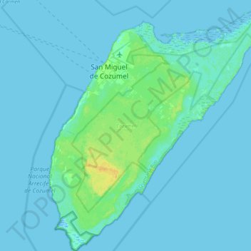
Nome: Mapa topográfico Isla Cozumel, altitude, relevo.
Local: Isla Cozumel, Cozumel, Quintana Roo, México (20.27200 -87.02520 20.59200 -86.72328)
Altitude média: 2 m
Altitude mínima: -3 m
Altitude máxima: 18 m
Obrigado por apoiar este site ❤️
Faça uma doação
Faça uma doação
Outros mapas topográficos
Clique em um mapa para visualizar sua topografia, sua altitude e seu relevo.