
Faça uma doação
Mapa topográfico Trois-Rivières
Clique no mapa para exibir a altitude.
Faça uma doação
Sobre este mapa
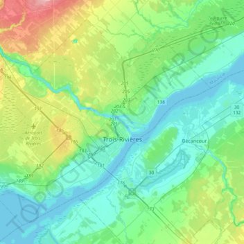
Nome: Mapa topográfico Trois-Rivières, altitude, relevo.
Local: Trois-Rivières, Mauricie, Quebec, Canada (46.25282 -72.77942 46.46915 -72.40878)
Altitude média: 36 m
Altitude mínima: 1 m
Altitude máxima: 148 m
Faça uma doação
Outros mapas topográficos
Clique em um mapa para visualizar sua topografia, sua altitude e seu relevo.
Mount Royal
Canada > Quebec > Urban agglomeration of Montreal > Montreal
The hill is part of the Monteregian Hills situated between the Laurentians and the Appalachian Mountains. It gave its Latin name, Mons Regius, to the Monteregian chain. The hill consists of three peaks: Colline de la Croix (or Mont Royal proper) at 233 m (764 ft), Colline d'Outremont (or Mount Murray, in the…
Altitude média: 111 m
Quebec
Canada > Quebec > Urban agglomeration of Québec
Quebec City was built on the north bank of the Saint Lawrence River, where it narrows and meets the mouth of the Saint-Charles River. Old Quebec is located on top and at the foot of Cap-Diamant, which is on the eastern edge of a plateau called the promontory of Quebec (Quebec hill). Because of this topographic…
Altitude média: 100 m
Faça uma doação
Faça uma doação
Mount Royal Park
Canada > Quebec > Urban agglomeration of Montreal > Montreal
The mountain is part of the Monteregian Hills situated between the Laurentians and the Appalachian Mountains. It gave its Latin name, Mons Regius, to the Monteregian chain. The mountain consists of three peaks: Colline de la Croix (or Mont Royal proper) at 233 m (764 ft), Colline d'Outremont (or Mount Murray,…
Altitude média: 110 m
Faça uma doação
Faça uma doação
Faça uma doação
Faça uma doação
Faça uma doação
Galerie d'amenée d'eau, Manic-5
Canada > Quebec > Manicouagan > Rivière-aux-Outardes
Altitude média: 339 m
Faça uma doação
Faça uma doação
Club de Plein Air Saint Adolphe d'Howard
Canada > Quebec > Les Pays-d'en-Haut > Saint-Adolphe-d'Howard
Altitude média: 399 m
Faça uma doação
Faça uma doação
Faça uma doação
Parc Marie-Claire-Kirkland-Casgrain
Canada > Quebec > Urban agglomeration of Montreal > Montreal
Altitude média: 24 m